Delicate Arch Trail
Arches National Park
Distance: 3.2 miles (5.2 km)
Cumulative Elevation Gain/Loss: 743 feet (227 m)
Date Visited: Tuesday, March 27, 2018
Delicate Arch Trail Map (KTNP)
When I think of Arches National Park, the iconic Delicate Arch immediately comes to mind. It’s the largest freestanding arch in the park. Images of it are everywhere – on tourism literature, Utah license plates, and more. And it was finally time for us to visit it. Frank Beckwith, the leader of a scientific expedition in the area between 1933–1934 is credited with naming the arch. And it is delicate. Some day Delicate Arch, formed by erosion of a sandstone fin, will fall.
The main 3.2 mile round-trip trail to the famous arch is, not surprisingly, very crowded. We went in the afternoon, but if you go very early in the morning or later in the evening, you may avoid some of the crowds. Besides Delicate Arch, there are nearby petroglyphs and the defunct Wolfe Ranch. Two additional trails to a lower and higher viewpoint are also nearby. They’re both easy hikes, so we decided to check them out first.
Lower and Upper Delicate Arch Viewpoints
The parking lot for the Upper and Lower Viewpoint Trails is a mile east of Delicate Arch Trail. The trail splits at the start, and we headed right to the lower viewpoint. The lower trail is only 0.1 mile. It’s an ADA trail, so it’s an easy hike on level terrain. However, the view isn’t that impressive since the arch is so far away, but if you don’t hike the main trail at least there’s this option. After checking that out, we went back to the split and headed onto the Upper Viewpoint Trail.
Getting to the upper viewpoint requires a 10-15 minute uphill climb with minimal scrambling. The trail is only 0.6 miles round-trip. It’s cool to get another glimpse of the arch, but again, not that impressive from this far away. It’s impossible to get to Delicate Arch from this area, as there’s a canyon called Winter Camp Wash in between. These trails don’t offer much more than a view, so if you plan to hike Delicate Arch Trail, you can skip them. We headed back to our car to drive to the main trail.


Delicate Arch Trail and Wolfe Ranch
It was time for the main trail to Delicate Arch. We arrived at the huge parking lot around 3:30 pm, and thankfully there was still parking. As we began the trail, we saw log cabins in front of us. This is Wolfe Ranch, settled by John Wesley Wolfe and his family around 1898. They were drawn to the area by a nearby freshwater spring. The Wolfe family lived on the property until they moved to Moab in 1910. The ranch was sold, and eventually purchased by the US government as part of Arches National Monument.
As we approached the ranch, we saw two buildings and a nearby corral. Old farm equipment lay scattered around. Visitors can’t enter or touch either building, but you can explore the grounds and look into the larger cabin through a screen door. It was built in 1906, when John’s daughter, Flora, moved to the area. Six people slept in the one-room cabin. Interestingly, Flora took the first known photograph of Delicate Arch in 1906.


After checking out the buildings, we continued along the trail and crossed Salt Wash. There was some water flowing but not a substantial amount. Seasonal flooding from the wash will occasionally close the road to Delicate Arch. The park is currently working on removing an invasive non-native plant called tamarisk that contributes to the flooding. We assume the water in the creek isn’t potable because of salt content, but we haven’t been able to confirm.
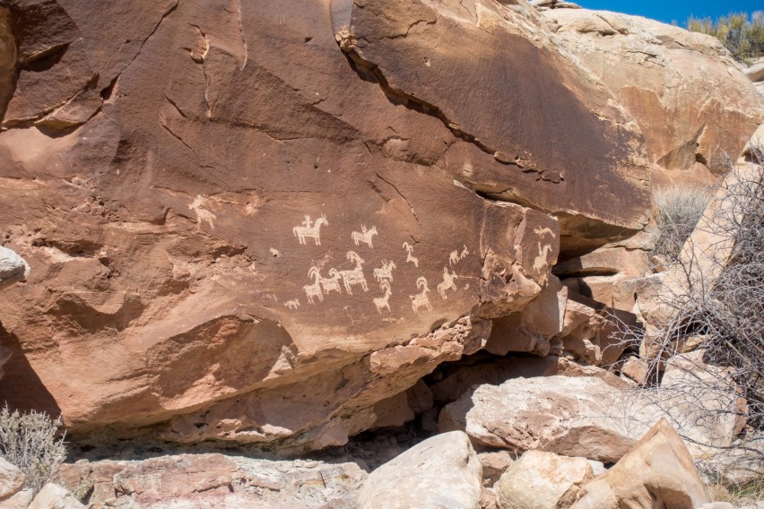
Immediately after the bridge, we turned left at a sign that simply said “Petroglyphs.” A short side trail leads to Ute Native American petroglyphs. They were inscribed sometime between 1650 and 1850, and they resemble horses and bighorn sheep. The area directly in front is fenced off so we could only get so close. It’s interesting to think about the people who carved them and their meaning.


Delicate Arch Trail
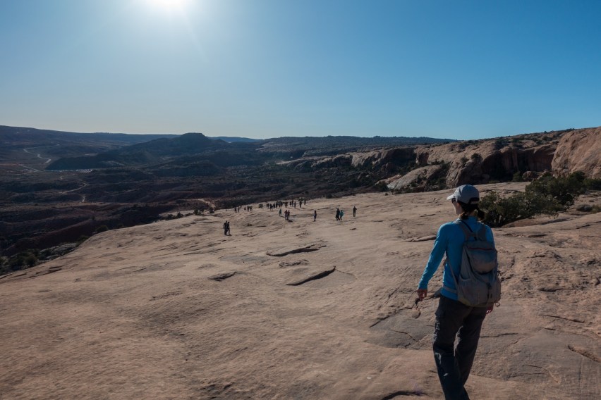
We rejoined the main trail, and started ascending a paved incline, which afforded us some views back to the Salt Wash area where we had just been. Reaching the top, we saw the trail dip down, then go up a huge sandstone slope. Large groups of people moved steadily onward.
There was no shade and it was getting pretty hot as we climbed. Please bring water; we saw people without it as they hiked. At the top of the uphill portion, we reached an area with some random cairns that people had made, next to a sign that pointed in the direction of the trail. (Note: creating cairns goes against the principles of Leave No Trace. This disturbs the natural landscape and can be confusing to hikers).
At this point, we followed the crowd since there were so many other hikers on the trail. Eventually we made it to a natural sandstone bowl. Directly across it was Delicate Arch! But there was no way for us to get to the arch from this direction (not easily at least). We realized we had missed a cairn and were on the wrong side of a sandstone fin. That’s what we get for following the crowd and not the cairns. Initially we tried to find our way up to Delicate Arch from here, but the route was sketchy, so we decided to backtrack instead. It was still cool to see a different view of the arch.


We backtracked until we found the trail again. It weaved around to the other side of the fin, where the path narrowed to three feet wide. A steep dropoff was on our left. It’s generally wide enough for two people, and it didn’t bother us, but I had read some visitors find it scary.
To our right was a slickrock incline that led to a small arch, called Frame Arch (also called Twisted Donut Arch). You’ll see why if you look through it – it literally frames Delicate Arch, so it’s a great place to take a photo. Unfortunately, there was a short line of people waiting for the same opportunity. It took about 10 minutes for one visitor to finish what they were doing before we could get an unobstructed view.
In 2016, someone carved their name into Frame Arch, severely damaging it. Thankfully, the park service was able to repair some of the damage by filling in the carving. But it’s still depressing that they had to do that in the first place. As a reminder, please leave no trace!


Delicate Arch
Continuing along the ledge, we ascended. As we came around a big rock, we immediately saw Delicate Arch. It seems to appear out of nowhere; you can’t see it from a distance as you approach like other arches. There were a lot of people scattered around the area, quietly observing the arch. Delicate Arch itself sits on the southeastern end of the bowl that we were at earlier.
Before we hiked the trail, Kristin wondered what the fuss was about. Now she understood the hype. Delicate Arch is a large, unique, freestanding formation, and the trail is challenging and enjoyable. We were glad we visited when we did, as the snowcapped La Sal Mountains provided a gorgeous backdrop for the iconic arch.
Nearby, visitors waited to get a photo with Delicate Arch. Everyone was quiet and respectful, which was much appreciated. After getting a close-up shot, we sat down and spent some time with the arch and got to know it a bit better. Before we knew it, it was time to go. We headed back the way we came. It was a bit scarier walking along the right side close to the ledge on the way down. After the hike, we drove to Moab and ate dinner at Milt’s – a super casual burger and fries type place that we recommend.
Delicate Arch is a treasure, so don’t miss it. The trail is somewhat difficult, and you’ll be surrounded by quite a few people, but it’s worth it. If you’re concerned about the crowds, try hiking it very early or later in the day. We loved the uniqueness of both the trail and the arch, and intend to visit again someday.


Delicate Arch Trail
Date: Tuesday, March 27, 2018
Type: Out and back day hike
Total Distance: 3.2 miles (5.2 km)
Cumulative Elevation Gain/Loss: 743 feet (227 m)
Time: 2.5 hours, including breaks
Trail Markings: Wayfinding Cairns
Difficulty: Moderate
Crowds: A lot everywhere
Water: None
Highlights: Geological Features, Views, Petroglyphs, History
Directions to Delicate Arch Trailhead: Google Maps Directions
Notes: It can get hot, so bring plenty of water. Try to hike in the morning or evening to avoid crowds.
Trail Directions
- 0.0 mi – From the parking lot head east on Delicate Arch Trail
- 0.1 mi – Turn left toward Wolfe Ranch. The trail will loop around the cabins, and back onto Delicate Arch Trail.
- 0.2 mi – Take another left toward the petroglyphs. The trail will loop past the inscriptions and rejoin the main trail.
- 0.9 mi – Begin ascending a large sandstone slope.
- 1.5 mi – Arrive at Frame Arch, and stop to check out the view of Delicate Arch through it. Shortly after Frame Arch is a narrow ledge that leads to Delicate Arch.
- 1.7 mi – Stop and enjoy Delicate Arch. Then return along Delicate Arch Trail.
- 3.2 mi – Back at the parking lot.
Places
- Wolfe Ranch | 38.736371, -109.519721
- Ute Petroglyphs | 38.73751, -109.51864
- Frame Arch (Also known as Twisted Donut Arch) | 38.744037, -109.501137
- Delicate Arch | 38.743594, -109.499281
Maps
Links
- Wolfe Ranch (NPS)
- Historical First Photo of Delicate Arch by Flora Stanley, 1906 (NPGallery)
- Removing Tamarisk at Salt Wash (NPS)
- Frame Arch Graffiti (NPS)
- Delicate Arch (NPS)

